China’s satellite network provides Iran with 24/7/365 coverage and real-time updates: SIGINT, terrain mapping, telemetry; radar, optical, and infrared all-weather/day & night imaging, allowing Iran to precisely strike Israeli and U.S. targets. No China, no “boom, boom, Tel Aviv!”

The Kill Chain
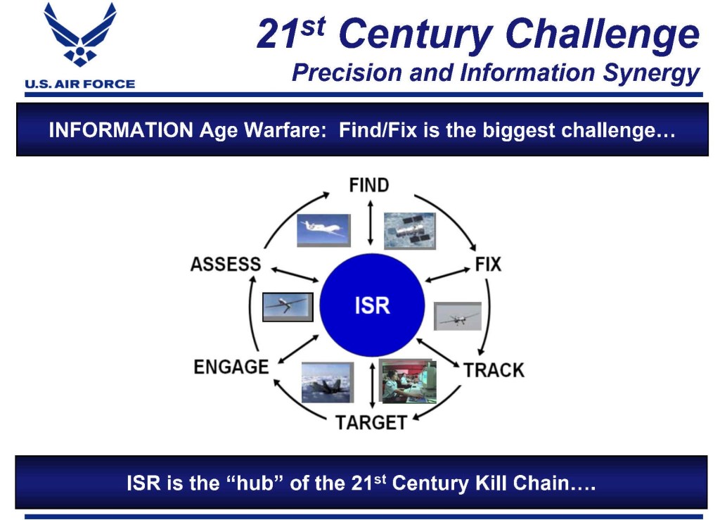
“Kill chain” is the sequential process used to identify, track, and destroy threats: Find, Fix, Track, Target, Engage, Assess. The six stages fall into two classes: “eyes” and “fists.” China provides the eyes; Iran provides the fists. China’s satellite network delivers full spectrum “Intelligence, Surveillance, and Reconnaissance” (ISR) coverage that Iran’s tiny satellite fleet cannot. Absent PLA’s eyes, IRGC punches in the dark.
Iran has two military satellites (Noor–1: decayed; end of life): Noor-2 (launched 8 March 2022), and Noor–3 (27 Sept. 2024); and two dual-use (mil-civ) sats, Khayyam and Pars–1. Noor–3 has optical imaging, 5–10m. Khayyam has Synthetic Aperture Radar (SAR) for high-resolution (≈1m) radar imaging. Pars-1 (track), has optical imaging, 10–15m res; SAR for all-weather radar imaging. However, SAR by itself is insufficient to distinguish between decoys and targets; for this, infrared (IR)—a class that includes thermal imaging—is necessary; but Iran’s fleet lacks IR. The fleet offers just basic geolocation capabilities, but for precise geolocation, two or more satellites must work together. Three are ideal for triangulation, especially for ships (in motion).
Iran’s tiny sat fleet cannot deliver persistent (24/7/365) all-weather, day/night imaging, ISR, and “signals intelligence” coverage (SIGINT), nor does the fleet have advanced equipment, e.g., 10–100m diameter antennae indispensable for SIGINT collection; optical telescopes ≥ 2m for high-res optical imaging; and advanced data processing systems. These features, and IR, are essential for targeting dynamic sites (assets that are frequently relocated and camouflaged, e.g., mobile air defense batteries).
China’s military sats (MILSAT), and dual-use or “civilian” sats, have superb SIGINT and imaging features (viz., ≥ 30m antennae and ≥ 2m optical telescopes)—Shijian–20, Gaofen–11, Yaogan–31, and Yaogan–41.
China: Find & Fix (satellites detect, identify, and geolocate targets);
China & Iran: Track targets (updates from China; Iran employs its radars and drones);
Iran: Target & Engage (ballistic missiles, cruise missiles, drones)
China & Iran: Assess (“Bomb Damage Assessment”; BDA)
Definitions: ISR and Satellites
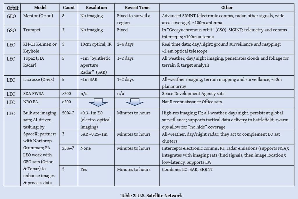
Chinese satellites deliver multilayered (different orbits) imaging architecture. Optical imaging includes very high-resolution (meters to cm) images (day only). For all-weather, day and night coverage, SAR can penetrate cloud cover. China also has multispectral and hyperspectral imagers (select members of Gaofen family) and video (dynamic surveillance of moving targets) through Jilin-1 sat constellations. Limited IR tech is on Gaofen–5, with advanced IR capabilities found in MILSATs (details are secret). The Fengyun–4B (FY–4B), at orbital station 105° E, has IR instrumentation for weather (it is likely dual-use).
ISR satellites vacuum myriads of signals from the ether. Subsets of SIGINT include “communications intelligence” (COMINT): landline and mobile comms (voice, SMS, data), radio chatter, Morse code, email, satellite transmissions; “electronic intelligence” (ELINT): radar and microwave transmissions; specifications of emitters; geolocation of signals.
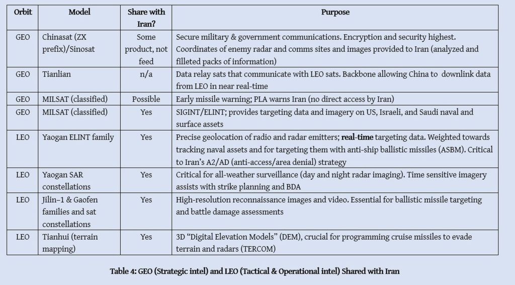
Data is processed in China and selectively shared with Iran, i.e., after PLA and/or MSS have analyzed and filleted intel. To protect sources and methods, intel is “filleted”—like beef—and only select “cuts” are served. Some intel—real-time data and time-sensitive info—is assuredly shared swiftly. China transferred ground- and ship-based ELINT platforms to Iran to augment collection and analysis.
ELINT, to illustrate, identifies the type of radar emitting signals, allowing for geolocation. Imagine that IDF has relocated an air defense battery to a street in Tel Aviv (pre-war intel on its location is now useless). The battery is identified when its radar emits, allowing PLA to analyze emissions, determine type, and precisely geolocate it. IRGC does the rest. Iran—and China—assess the outcome (BDA).
In the real-world situation below, PLA did the find & fix bit (identify and geolocate); IRGC did the track, target, & engage part.
Common Satellite Classes

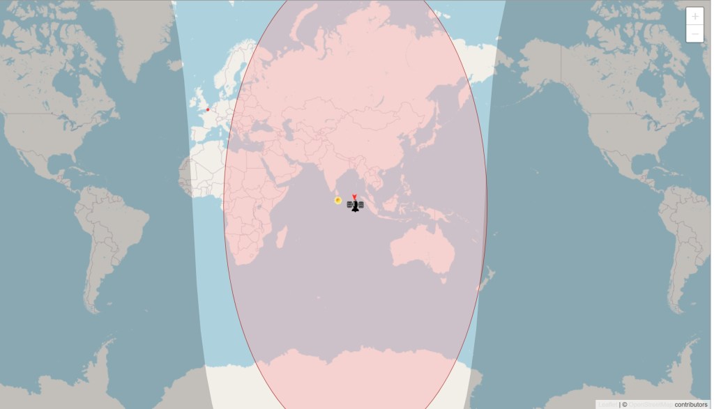
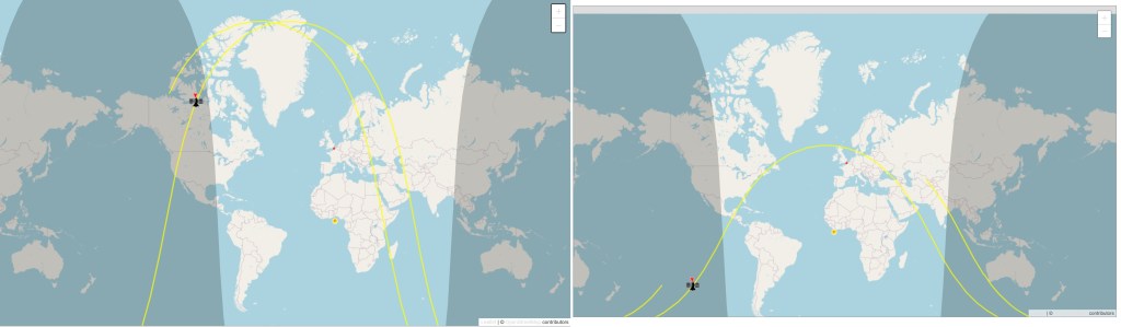
(1) Geostationary orbit (GEO), ≈ 36,000km altitude, 24 hour orbit fixed to earth’s surface (for fun, track CHINASAT-9C); primarily for SIGINT, offering persistent coverage of specific areas (see Table 5). GEO comprise about 5% of (≈ 7,560) active satellites.
(2) Medium Earth Orbit (MEO), 2,000–36,000km, 2–24 hours per orbit, for navigation (GPS, Galileo, GLONASS, BeiDou), ≈2% of satellites.
(3) Low Earth Orbit (LEO), 160–2,000km, ≈90–120 minutes per orbit, ≈90% of sats, for high-res imaging, SIGINT, telemetry, tactical communications, and data relay, with the ability to rapidly revisit covered areas.
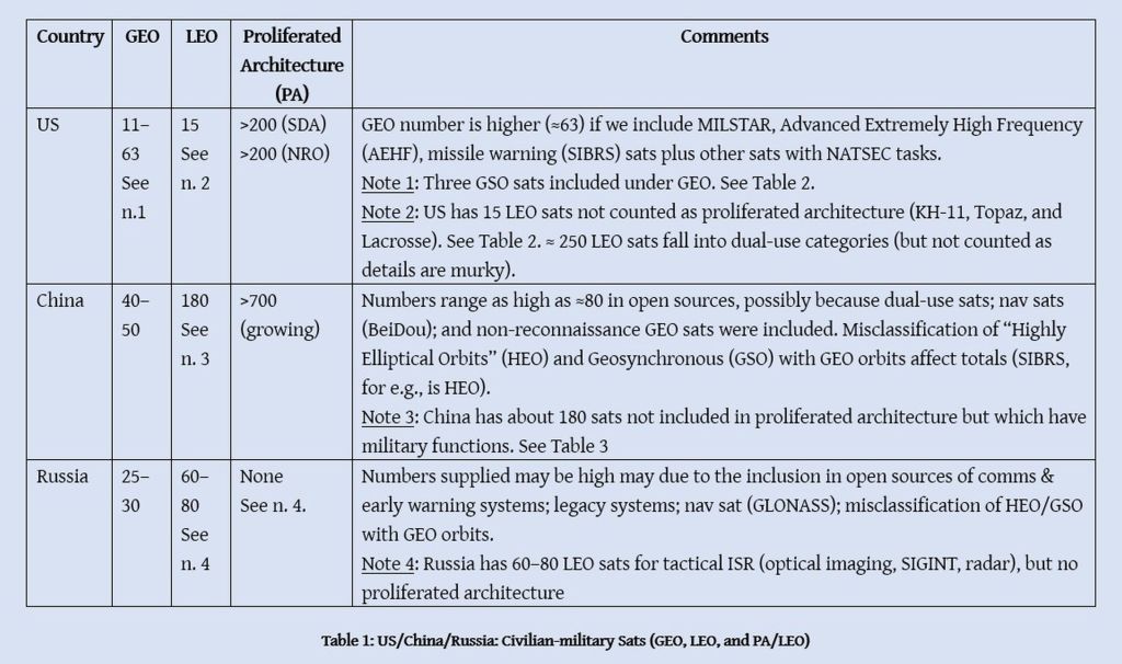
LEO/MEO/GEO ratios show LEO dominance (85–90%). Starlink (≈8,000 are operational sats) are not included in my LEO statistics. Some Starlink, though not NRO sats, offer battlefield support to US/Israel (as in Ukraine). China is developing its Starlink equivalent.
Proliferated Architecture (LEO Sats)
In recent years, U.S. and China moved to “proliferated architecture” (PA) sat coverage, i.e., large quantities of relatively small, low cost LEO satellites, distributed at dissimilar orbital layers, covering the globe.
PA includes constellations of satellites that operate as a “team”; for example, China’s Yaogan family are constellations of 3+ sats, individually tasked, working cooperatively to deliver full spectrum ISR. By operating in pairs or clusters, apart from distinct taskings, they geolocate precisely. In maritime surveillance, three sats triangulate a ship’s location. Constellations are situated to cover critical regions (e.g., Middle East, Indo-Pacific).
PA networks and their constellations of sats are flexible (maneuverable), upgradeable (short upgrade cycles), layered (dissimilar tasks), and low latency (signal roundtrip from sat to station in milliseconds: GEO, ≈250ms; LEO, ≈20–25). GEO sats are costly, few, and vulnerable to anti-satellite weapons (ASAT); but LEOs, through scale, continue ISR tasks if sats are destroyed. Moreover, a new sat can be maneuvered to replace the destroyed sat(s). Sats engage in swarm tactics to provide comprehensive ISR coverage.
PA deliver “no hide” coverage. In the “good old days,” targets knew KH-11 pass schedules and played possum until the sat passed. Targets cannot do this today with PA assets carrying all-weather, day/night radar, optical imaging, and IR payloads saturating sites 24/7.
U.S. has two layers of PA: (1) “Proliferated Warfighter Space Architecture” (PWSA; by Space Development Agency (SDA); and (2) PA by National Reconnaissance Office (NRO). The first, 200+ LEO sats, form a mesh network for high-speed data transport. The second, 200+ LEO, for ISR. Details are murky. Since focus is China and Iran, I have not dwelled on (1) or (2).
Notes and Caveats
Sats are assigned unique identifiers: COSPAR and NORAD. Sats can be tracked real time by name (e.g., Khayyam) or ID (Khayyam: NORAD ID 53370; COSPAR 2022-096A; Pars–1: NORAD ID 59065; COSPAR 2024-039Q), but most NRO sat locations are obscured. U.S. adds Chinese sats, including ISR sats, to databases with NORAD and COSPAR IDs. China obfuscates sat names; for e.g., Yaogan (“remote sensing”) and Shijian (“practice”). NB: Iranian sats are assigned NORAD ID but possibly identified in databases as “OBJECT__” (Pars–1 is “OBJECT Q”), or as “decayed” (e.g., Noor-2 and Noor–3), probably to block tracking by the public. Noor–3, launched less than one year ago, should not be “decayed,” but Noor-2 is close to end of life. A scientific union has an Excel database (to 1st May 2023; updated PDF) of sats (some NRO sats are identified). See also CelesTrak, Space Trak, and ISS Tracker.
Numbers utilized in the tables are not dispositive. They are just best estimates given the morass of data. Moreover, totals and technical specifications are classified. Identification of class, units, functions, and locations of sats is challenging.
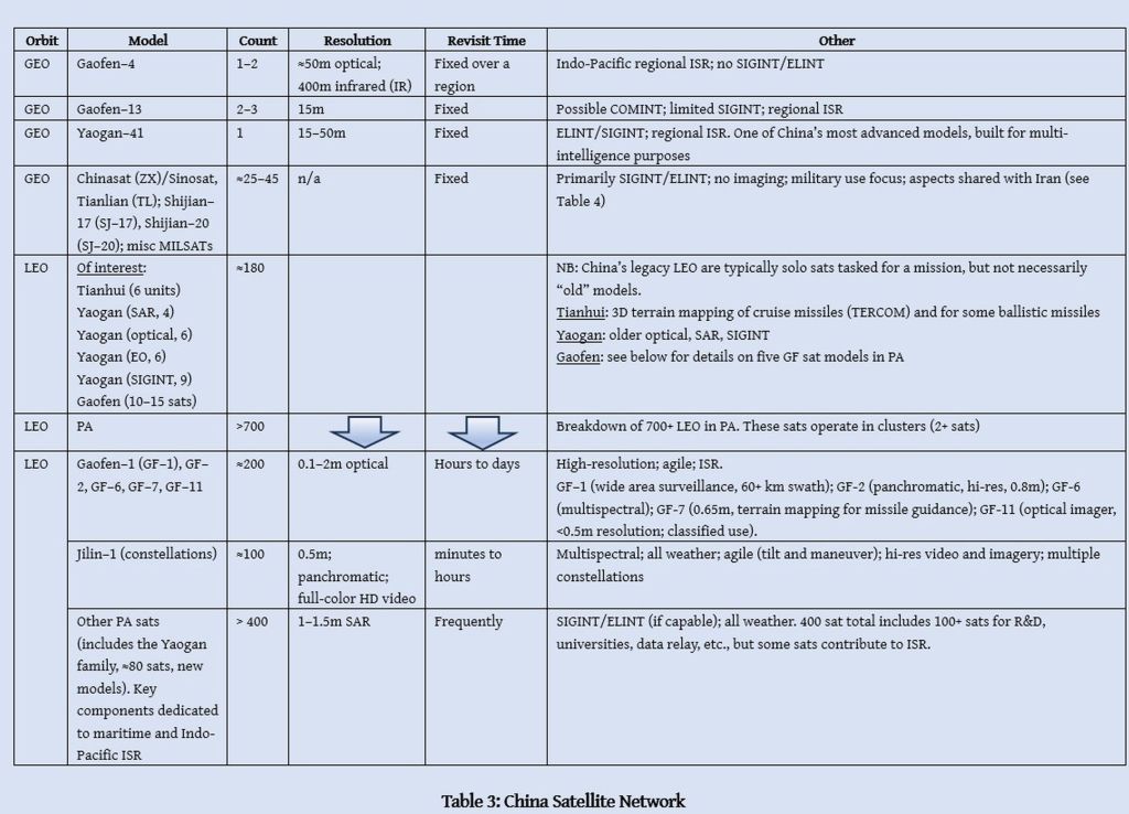
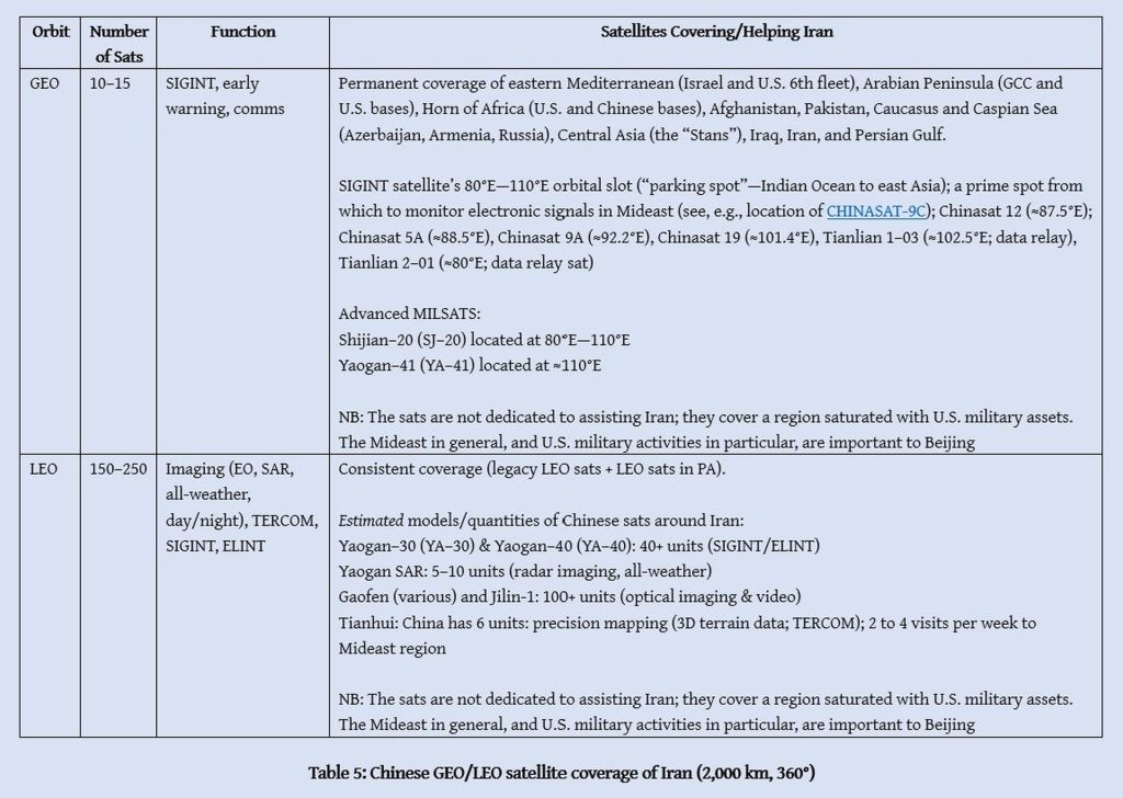
The Yaogan family (≈16 LEO models; one GEO model) are military-dedicated sats; they warrant individual study. About 80 units are operational; ≈50% carry payloads for naval ELINT. Majority of the maritime-focused Yaogan are likely positioned over the Indo-Pacific region. A constellation with naval ELINT is covering the Persian Gulf, along with a Yaogan SAR constellation and Yaogan-30 SIGINT constellation (see Table 5).
Jilin-1 (≈100+ units total, tasked in clusters) is commercial, but its hi-res optical imaging makes it dual-use. I have not identified in tables sat models such as Beijing-3 (≈3 units, hi-res imaging), Hainan-1/Zhongzi (≈6 units; maritime surveillance), and Shijian-20 (most advanced SIGINT and comms sat) since specifics are scarce, but I have included them in estimated totals. The purpose is not to analyze sat specifications, but to broadly identify classes and quantities of sats that are probably supporting Iran. China dedicates most of its sats to cover the Indo-Pacific, but retains surge capacity (20–30%?) for re-tasking. Sats in 80°E—110°E orbital slot cover Middle East (see CHINASAT image above; Table 5, below).
NRO’s Satellites
China’s Satellites
ISR Cooperation with Iran
Remarks
China and Iran: Military Cooperation
Integration of Iranian military systems with Chinese ISR systems began at least a decade ago. Iran’s migration to BeiDou satellite navigation system—alternative to U.S.-controlled GPS—is instructive. Migration began in 2015. Commentators gushed that Iran “ditched” GPS for BeiDou in the Twelve-Day War, but developing technological architecture was conditio sine qua non for migration. Iran established ground stations (2015–18); received BeiDou–2 (pre–2020) & –3 (post–2020) tech and training; upgraded military and civilian software and hardware to utilize BeiDou’s encrypted signals. Migration was completed in 2025.
China and Iran do not admit to ISR cooperation; both side issue vague statements about “technical cooperation,” etc. But there are logical means to establish the “eyes and fist” arrangement. Noor-2 is nearing decay, leaving Noor–3 as the sole confirmable military sat that is active. The orbital paths of Khayyam and Pars–1 show low coverage of the Middle East. Both are in sun-synchronous orbit (consistent sunlight) at 97.4° and 97.5° inclinations, respectively, imaging in daylight the same locales in the Middle East at the same time each day (2–3 passes per day per sat; 10 mins per pass per sat). This is insufficient.
Iran requires persistent, full-spectrum (eyes & ears) coverage—not just during the Twelve-Day War, but every day—that its sats cannot deliver. Iran, as discussed, lacks GEO SIGINT sats, very high-resolution optical imaging, IR, geolocating, terrain mapping, advanced SAR, multispectral and hyperspectral technologies; proliferated architecture (LEO constellations, as noted, deliver multilayered “no hide” coverage).
The coverage that Iran needed in the Twelve-Day War could only have come from China. Russia, apart from its own distractions, has no proliferated architecture and few LEO sats in its inventory to share. Indeed, it is believed that Khayyam is imaging Ukraine for Russia. Tasking of Chinese LEO sats (proliferated architecture and “legacy” LEO sats to the Mideast); diversity of GEO sats in 80°E—110°E orbital slot (see Table 5); and high revisit rates by LEO sats (PA and non-PA), show that PLA satellites are Iran’s “eyes and ears.”
It is improbable that Iranian ISR drones penetrated Israeli airspace during the war, or that Iranian radar systems located dynamic targets by themselves (pre-war intel is virtually useless once assets are relocated). Yet, Iranian missiles found relocated targets and struck them accurately (we witnessed IDF batteries get blasted frequently). That happens only with real-time data and precise geolocation. Launches by Iran or Yemen of one or two ballistic missiles were designed to bait air defenses into activating radars, allowing an ELINT partner to “find and fix.” Yemen, derided by Israel for “missing” targets, assuredly did a lot to help IRGC and PLA map the multi-layered (sea and land) air defense network protecting Israel, and acquire detailed electronic fingerprints.
China and Iran: Strategic Alignment
A commentator claimed that “Iran’s Foreign Policy Is Changing in Real Time,” to wit, Iran is moving closer to China. This may be so for “Reformists” and segments of the Iranian public “mugged by reality” in the Twelve Day War—that the U.S. is a faithless negotiator, and Iran will never secure economic benefits from a West that is slavishly-devoted to Israel. Iran’s realists—the maligned “hardliners”—were smarter. They knew that economic and military integration with China was indispensable for Iran’s prosperity and survival, not just as an Islamic Republic, but as nation-state given U.S-Israel plans to partition Iran.
China has been a steadfast ally since the Iran-Iraq War (1980–88)—unlike USSR/Russia, which supported Saddam; reneged on its S-300 SAM contract; and failed to deliver Su-35 jets that Iran desperately needs. The Kremlin faces pressures from Zionists in Russia and one million Russian rejects in Israel. China has no Jewish population or Zionist lobbies capable of blocking economic and military cooperation. Moreover, China, unlike the U.S., advances its own national interests. Iran is integral to China’s grand strategy.
The “China-Iran 25-Year Cooperation Agreement” of 2021 (see Appendix) is an aspect in the Beijing-Tehran relationship, but it does not define it. From Beijing’s strategic perspective, Iran is its most important tool for dislodging U.S. military-political influence in the Middle East; and for advancing China’s long-term ambitions: military influence (regionally and globally), trade, and transportation and energy security. China is using Iran to exhaust (or expel) CENTCOM forces without sacrificing a single PLA soldier.1
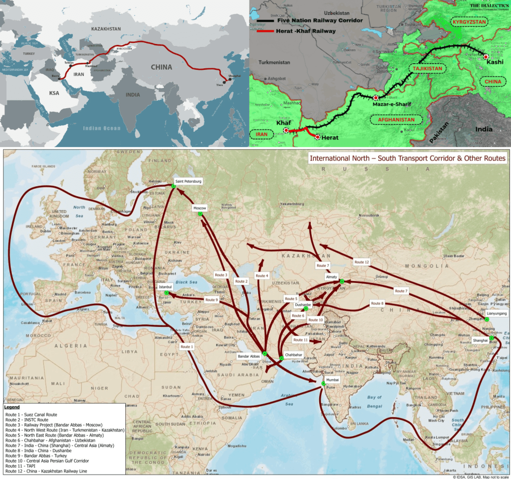
Maritime routes are crucial to China. Beijing knows that sea routes can be harassed, but overland (railway) routes inaccessible to U.S. Armed Forces guarantee connectivity. Iran is China’s metaphorical and literal “bridge” to the Middle East and Persian Gulf. Hence Iran’s centrality in the Belt & Road Initiative (BRI). “Regime change” in Iran would cripple BRI, and sunder the Iran-Russia-China multipolar bloc.
Iran compels U.S. to divert military assets to the Middle East, reducing pressure on China in the Indo-Pacific; and Russia and Iran deplete U.S. military inventories (see “Depletion of U.S. Interceptor Stockpiles”). Relatedly, China tests military technology through Iran, and acquires military and technical intelligence on U.S. capabilities. For example, during the Twelve-Day War, PLA obtained through its satellites, two type 815A ELINT ships2 in the Persian Gulf, and Iranian intelligence, data on, inter alia, U.S. air defense systems. Every time AEGIS or THAAD radars light up, PLA’s sats and ELINT ships vacuum oodles of data). China obtained real-world data on how U.S. air defenses operate3 (radar signatures, interceptor performance, network resilience, etc.), allowing PLA to adapt warfighting doctrines, EW measures, missiles, and MIRV/MaRV warheads.
In the interests of space I have confined myself to highlighting a few benefits to China and Iran of their intel sharing arrangement. U.S. suspects China’s roles, but Tehran, to help Beijing maintain “plausible deniability,” does not publicize their “eyes and fists” pact. For instance, when Iran struck al-Udayd, Trump gave a cock-and-bull story of how eleven of twelve Iranian missiles were intercepted and one missile caused minor damage. Tehran did not contradict him by publishing BDA images. However, weeks later, commercial sat images hit the internet, showing precise hits and heavy destruction. Open-source images of the 2024 strikes in Israel just emerged, showing precision hits.
If Iran publishes Chinese BDA images, Tehran will have proven Beijing’s involvement; and given western intel analysts insights into specifications or capabilities of China’s ISR sats. Tehran sucks up Trump’s insults while steadily grinding down U.S. military power in the Mideast with China’s ISR and technical assistance. 謝謝
Appendix
China-Iran 25-Year Cooperation Agreement (2021)
Tehran’s military-intelligence relationship with Beijing is not defined by a piece of paper. The agreement signed 27 March 2021 has not been published, but a “fact sheet” supplied by the Iranian Foreign Ministry is available. Reports claiming values for Chinese investments in Iran, or specifics on areas of cooperation, are unverifiable.
- Should the U.S. flee Mideast like they did Afghanistan, China will not have to fight U.S. over Taiwan. Taipei will telephone Beijing to initiate unification talks. ↩︎
- The 815A ELINT ships are said to be able to detect emissions from stealth aircraft (B-2 and F-35), but cannot precisely track them. ↩︎
- Not just U.S. and Israeli systems, of course, since Brits, French, Germans, Italians, Jordanians, Saudis, Qataris, and Emiratis attended the parties that Iran threw one to three times per day for twelve days. PLA doubtless acquired comprehensive electronic fingerprints on U.S. and NATO systems. ↩︎

You must be logged in to post a comment.